
La Sal Mountains Viewpoint
La Sal Mountains Viewpoint
Explore this 360 View of La Sal Viewpoint!
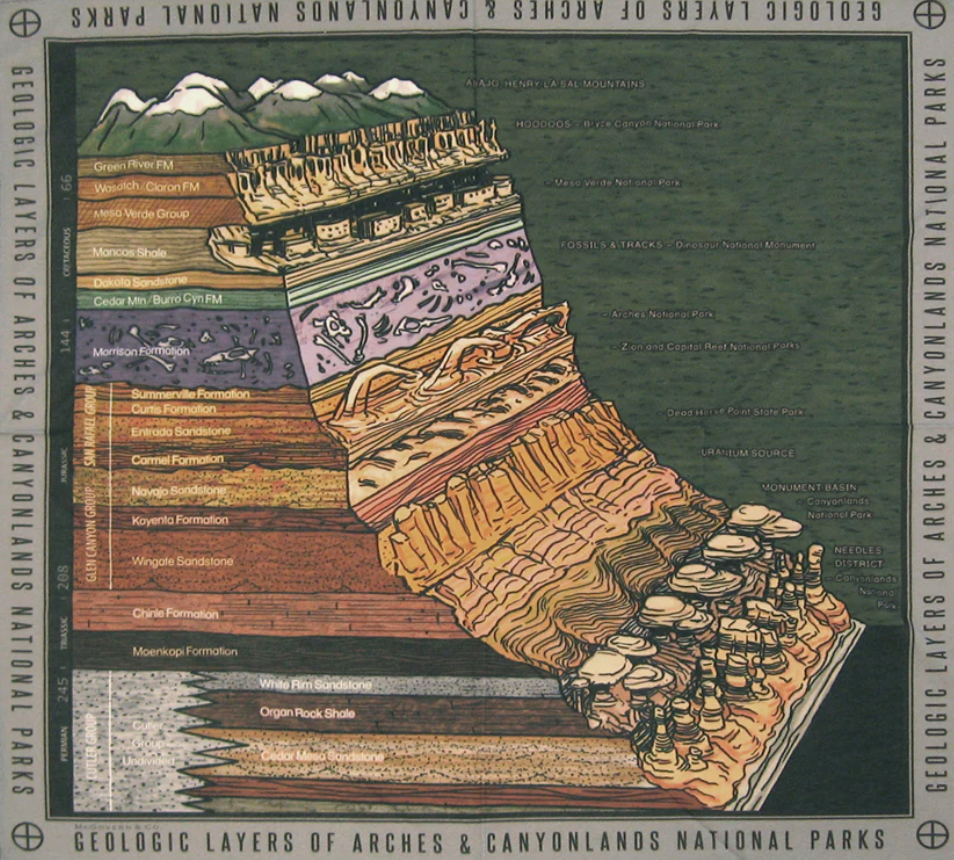
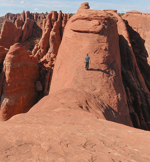
La Sal Mountains Viewpoint is one of the first stops out of the Visitors Center in Arches National Park that puts eyes on some of the sublime rock formations located throughout the park.
The formations are part of the Courthouse Towers area. In the 360 video, the closest two formations on the right and left are unnamed monoliths, columns isolated from other rock formations. The several formations in the Courthouse Towers area are classified as sandstone pinnacles, monoliths, and walls.
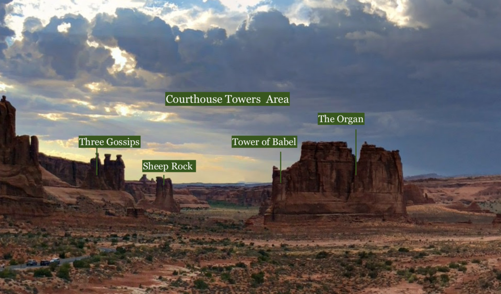
In between the pinnacles you can see The Organ, Three Gossips, Sheep Rock, and a little bit of Tower of Babel.
The photo below shows the 10 mile stretch of the La Sal Mountain Range. The tallest, Mt. Peale, looms at a height of 12,750 feet, it is the pointed peak at the center-right. It is named La Sal Mountains Viewpoint as you can see the La Sal Mountains in the distance due east.
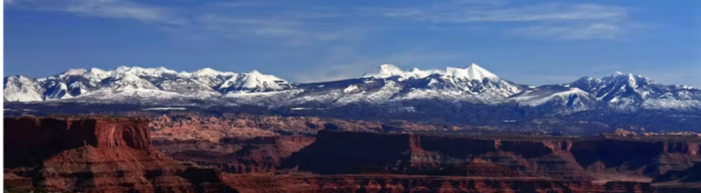
Photo: njn8734
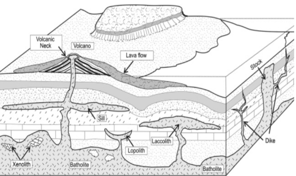
The La Sal mountains are laccoliths. Laccolith mountains form from igneous intrusions where magma is fed from below and forces its way up through the crust, doming the crusts upper surface. The melt horizontally spreads out and pushes up on overlying units. Basement faults allowed magma to neck up and chew into sedimentary layers at La Sal. In laccoliths, layers melt, push apart or get broken through to make way for the buoyant hot material. The magma cooled and solidified before it reached the bulging surface turning into intrusive igneous rock. If the magma would have reached the surface there would have had an erupting volcano on our hands!
The sedimentary layers that once covered La Sal Mountains have eroded away and exposed the sizable mountain range in an otherwise level landscape. These mountains are 25-28 million years old and have a dioritic composition, abundant in hornblende and plagioclase. The name itself means “Salt Mountain”.

The Entrada Sandstone is pale reddish-orange silty sandstone containing interbedded mudstone with a thickness between two hundred and five hundred feet. It is a slope forming unit which gives us those tall walls of cemented sediment. It erodes into fins, spires, mesas, windows, arches, etc. The grains of the Entrada Sandstone are nearly spherical making the rock porous and permeable.
Photo: Canyonlands
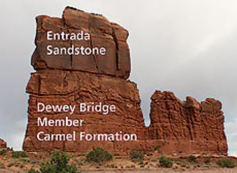
The Carmel Layer beneath the Entrada is made of mudrock and sandstone interbedded with gypsum and limestone with a thickness of one thousand feet.

Beginning in the late Paleozoic, Utah was a shallow marine environment. Over the following 15 million years, sea levels rose and fell, trangressed and regressed, a whopping 29 times. All the while salt was being depositing in Paradox Basin which contains Arches National Park.
photo: (Doelling,1985)
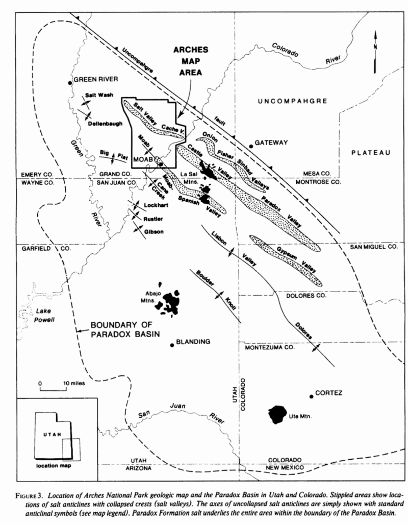
Halite, and other evaporites, specifically gypsum and anhydrite, accumulated over this time forming vast salt beds. The water eventually completely evaporated out of the basin leaving a floor of 14,000 feet (R.J Hite, 1968) thick of salt. The evaporite deposit in Paradox Basin was buried beneath sediment for the next 300 million years. The overlying sediment homogeneously cemented into rock layers, most prominently in the Entrada and Navajo Sandstone formations which are found in Arches.
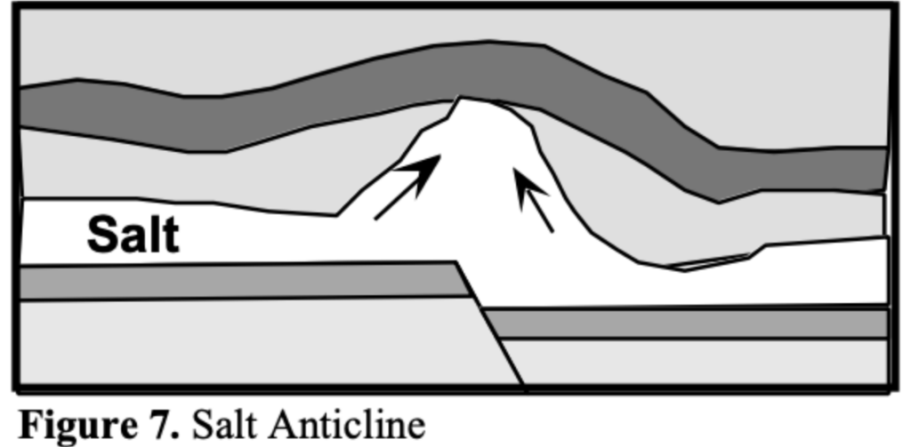
Because salt has low density and high ductility it flows under pressure. At a greater burial depths and higher temperatures, salt deposits becomes less dense than overlying strata. The higher temperatures at depth cause the salt to heat and expand, further increasing its buoyancy.
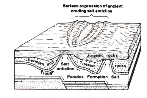
In Arches, the underlying salt was more buoyant than the sediment it had been buried beneath so it rose to the surface forming a salt dissolution feature called a salt diapir or salt dome. The salt dome formed an anticline which deformed the overlying strata by cracking the sandstone cap rock, creating parallel, vertical fractures called joints in the sandstone.
As the youngest layers on top of the salt and cap rock eventually eroded away, the jointed sandstone became exposed at the surface. This subjected the sandstone to the elements!
The open spaces where the rock was cracked open allowed water to flow in, which dissolved away the salt that has been exposed beneath the sandstone. Eventually the dome became depleted of the evaporites and collapsed to create a valley. Thin sandstone rock walls called fins, named for looking like fish fins, are the remnants of this process. The space between each fin ever widens as the sandstone erodes over time.
The formations seen here are fins that are continually being sculpted by the elements!

Wind travels relatively uninhibitedly throughout this desert landscape, as there are not large trees or obstructions to slow it down. It essentially acts as a sand blaster that can whip with reckless abandon on the fins. This is an aeolian process known as abrasion.
Roughly 9 inches of rain fall annually in the area. The slightly acidic rain water combines with carbon dioxide in the air creating carbonic acid. This erodes the fins by dissolving the cement, calcium carbonate, that hold the grains together. This is chemical weathering process known as chemical dissolution.
In the winter months water seeps into small cracks in the fins and freezes into ice. The expansion of the water as it freezes acts as a wedge that opens the rock, further cracking it open. This is a physical weathering process called “ice-wedging”.
Temperatures in the park can oscillate between freezing and melting in the span of one day during the cold season. Ice, Ice Baby! This process is constantly reworking the landscape.
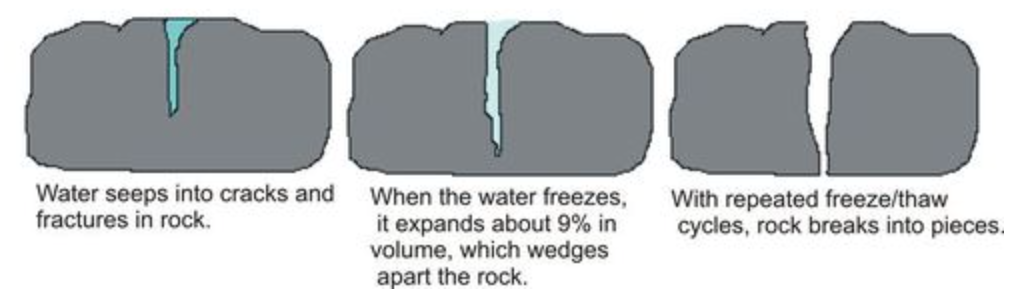
Ice wedging plays a huge roll in the breakdown of the rocks, sculpting them into the gorgeous features we see here.
Check out our other Virtual Field Trips to get a full scope of Arches National Park!
Author: BreeAnn Getman