
Grand Canyon
Welcome! Explore America’s most astonishing, breathtaking, downright geological meccas!
Your jaw has just dropped a little over a mile in the the chasm below. Your chin is wet with waters from the Colorado River, which still flows through the canyon today, carving deeper yet into the basement rocks in the inner gorge. We are at Bright Angel Trailhead. Kolb studio is seen on the right and Maricopa Point to the left.
Kolb Studio, the house in the photo, is a historic Victorian home now property of the National Park, was once owned and operated by the Kolb brothers, who were explorers and photographers of the natural beaut here.
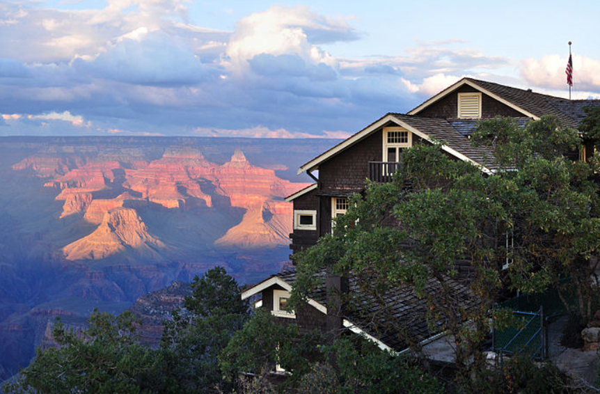
You can see roughly 10 miles across to the chasm. This location is on the South rim of the grand canyon. Across the canyon is the Northern rim. Luckily, thanks to the principal of lateral continuity, the rock on south side and north side are exactly the same.
The depositional story of the rock formations that create the Grand Canyon Super Group is one of rising and falling sea level, erosion, uplift, and eventually downcutting by the Colorado River forming the canyon we see today.
The Grand Canyon is 277 miles long, beginning at Lee’s Ferry and ending at the Grand Wash Cliffs.
It exists as the eroded product of the Colorado Plateau. Plate tectonics uplifted the rocks and interestingly, did not deform them!
Typically, this kind of tectonic activity distorts and deforms the initial horizontal sedimentary rock layers, causing them to become significantly tilted and contorted. This is true of the Rocky mountains and Basin & Range areas nearby, but this area was uplifted 9,00 feet and remained relatively horizonal.
The geology of the grand canyon may look difficult on a topographical map but it couldn’t be more simple. It follow’s layer cake stratigraphy and it’s topography follows the downcutting of the Colorado River that eroded the plateau into a canyon.
In the area, monoclines are the exception to the horizontal M.O. of the Grand Canyon. Monoclines describe a step-like fold in strata giving it the flat-ramp-flat geometry as seen in the photo below.
65 million years ago, faults located in the basement rocks that were responsible for the break up of the supercontinent, Rodinia, were reactivated during the Laramide Orogeny. As they say, once a fault, always a fault! When the faults reactivated, the overlying sediment upwarped as the basement rock’s hanging wall rose upward.
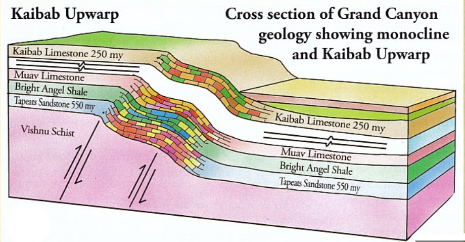
The monocline is responsible for the south side of the Grand Canyon being roughly 1200 feet below the North side. The difference in elevation often leads to the North side of the canyon to be closed due to icy conditions, while the Southern rim usually stays open year around.


The photo below is an excellent illustration of the Grand Canyon’s stratigraphy. Stratigraphic columns, show the chronological order of deposition, with oldest layers on the bottom, youngest on top, and give their relationship to the geological timescale. There are three sets of rocks here. The Layered Paleozoic Rocks, The Grand Canyon Supergroup, and the Vishnu Basement Rocks.
The story of the canyons deposition requires a good geologist to understand the depositional setting of these sedimentary units in relation to rising and falling sea level.
Marine Trangression: rising of sea level
As sea level advances inland the shore also moves to higher ground.
Marine Regression: lowering of sea level
Sea level retreats, transitioning the former sea bottom into land.
Comprising numerous layers representing various time periods and geological events, the majority of the rock formations were deposited as a result of the ebb and flow of ancient ocean shorelines, influenced by shifts in climate. During colder periods, when ice was more extensive, coastlines receded, whereas warmer conditions with reduced ice led to rising sea levels. (Kolleger,2017)
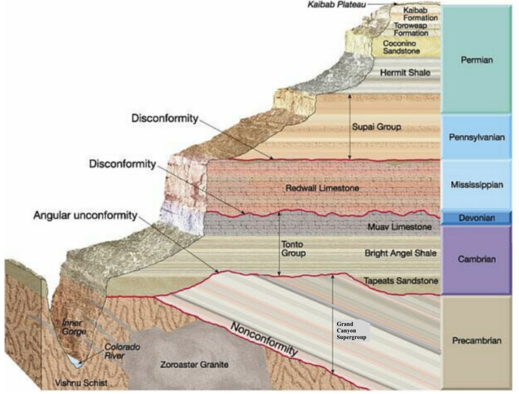
Photo: Rocdoc Grand Canyon Stratigraphic Column
Kaibab Formation
PERMIAN
270 Mya
The youngest unit, which you are standing on in the video, is the Kaibab Formation. It is the cap rock of the canyon! It is a white to gray limestone replete with marine fossils such as worms, mollusks, sharks, & corrals. It is a resistant cliff forming unit that was deposited in an oceanic environment formed by marine transgression.
Toroweap Formation:
PERMIAN
273 Mya
Slope-forming unit deposited in the trangressing waters of a shallow sea. It is composed of three slope-forming sections in the formation.
- Seligman Section- sandstone and siltstone
- Brady Canyon Section- gray limestone with sprinkles of chert
- Wood Ranch Section- red and gray siltstone & dolomitic sandstone
Coconino Sandstone
PERMIAN 275 Mya
Buff white cross bedded sandstone containing fossilized lizard, scorpian, and millipede tracks. The Coconino is a massively bedded non marine aeolian sandstone. At this time in the Grand Canyons history, this area was dry land. The seas have completely retreated and left great sand seas, called ergs, that were eventually cemented into sandstone. It is composed mostly of quartz and potassium feldspar and is a cliff-forming unit.
Hermit Shale
PERMIAN
280 Mya
Slope forming reddish brown siltstone, mudstone, interbedded with red and white sandstone and siltstone. The sediment was deposited in a delta, at sea level on the shoreline. Some plant fossils are present in the strata.
Supai Group
PENNSYLVANIAN TO LOWER PERMIAN
315 Mya
This group is mostly siltstone and mudstone depostited on land. Fossils of land plants are present in the strata denoting marine regression. The Supai Group consisnt of 4 formations.
- Esplanade Sandstone(youngest): Pennsylvanian-Permian boundary consisting of fine-grained cross bedded sandstone. It is the thickest formation in the Supai Group
- Wescogame Formation: Conglomeritic marine deposition
- Manakacha Formation:Calcareous sandstone and shaly mudstone. Records rising ocean levels
- Watahomigi Formation(oldest):Red sandstone, sandstone, tan limestone. Contains brachiopod and other marine fossils. Records marine transgression.

Redwall Limestone
MISSISSIPPIAN
340 Mya
Massively bedded cliff-forming dark brown to blue-gray limestone and dolomite with white chert inclusions. Abundant fossil record of marine brachiopods, crinoids, and corals. Records marine regression.
Usually limestone is slope-forming but in arid environments, it is cliff-forming

Tonto Group
CAMBRIAN
505-525 Mya
This was a time of marine transgression
- Muav Limestone: Dark gray to rusty orange thinly bedded mottled dolomite, white sandy dolomite, and limestone with thin beds of shale, siltstone, and conglomerite. Forms cliffs or small ledges. Burrows, sponges, & trilobites are present but poorly preserved
- Bright Angel Shale: Green, purple, and reddish brown thinly bedded shale, siltstone, with thicker beds of brown sandstone and dolostone. The most fossiliferous of the Tonto Group, ichnofossils, trilobites, and bryophyte-grade cryptospores.
- Tapeats Sandstone (oldest): Relatively resistant tan and reddish brown cliff-forming conglomeratic sandstone. It is interbedded with mudstone towards the base of the formation. It is very rich in burrows and trails but poor in body fossils. Tapeats is completely lacking in trilobite and brachiopod fossils.

Grand Canyon Supergroup
740-1200 Mya
PRECAMBRIAN
The Grand Canyon Supergroup is divided into the Unkar terrane, Nankoweap Formation and Chuar terrane. These are sedimentary and volcanic formations, including a 1.25 billion year old limestone with the earliest life fossilized in the rock. Guess what it was. Algae! You go, Algae! Fossilized algae is called a stromatolite. The supergroup here was faulted, uplifted, and tilted. They have a 10-15 degree dip angle!
You can learn more about the units here


Vishnu Schist
1.7 Bya
PRECAMBRIAN
Oldest, deepest layers in the canyon. They are the metamorphic and volcanic basement rocks that form the inner gorge.
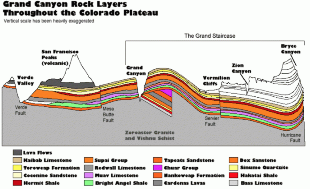
The geology of the Grand Canyon is heavily connected to most of the American Southwest. The same units that here are deeply buried under Zion and Bryce Canyon. There is really something to behold here. Nature’s great power of erasure leaves great mysteries and unconvers unfathomable beauty as seen in the Grand Canyon.
Be sure to check out our videos in Utah for related geology!
Author: BreeAnn Getman