
Delicate Arch
Delicate Arch
Delicate Arch seen in this 360 VR video is Utah’s most famous arch!
You may recognize it from the Utah’s license plate or maybe when the 2002 Winter Olympic torch relay passed through this arch. Perhaps you caught a glimpse of it in 2003 film The Hulk. I do declare, there is nothing like experiencing it up close and personal. This is the Beyoncé of arches, the megastar of the park!

Delicate Arch is a natural freestanding arch, meaning it is not attached to any wall or cliffs. It stands fiercely independent with incredible grace and elegance. It towers 65 feet in the air, with the opening being 46 feet tall and 32 feet wide. Thats about the height of 7 doors stacked on top of each other, or 2 giraffes!
The arch may look fragile but it is actually a quite stable structure. It is created through weathering processes that make all the arches in the park. We are privileged to be alive to behold it for it will not be standing forever.
The lifespan of arches is variable and depends upon several factors such as erosion rates, composition of rock & structural integrity, climate & weather, earthquakes, and human activity.
Delicate arch has been standing for thousands of years and will hopefully stand for a thousand more. In the 1950’s the National Park wantee to apply a clear, plastic coating on it to protect from its eventual destruction throough the very erosional processes that created it! For better or worse, it was decided too impractical.

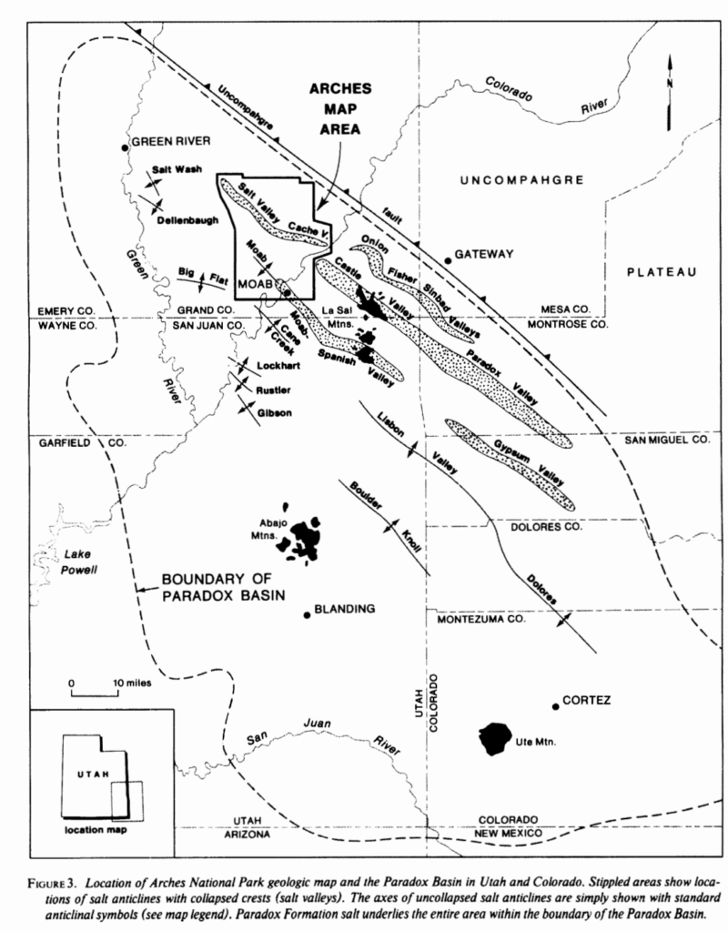
Arches is located in Salt Valley. Salt tectonics played a large roll in arch formation. Salt Valley, formally known as Paradox Basin was a shallow marine environment.
In the late Paleozoic sea levels rose and fell, all the while depositing salt.
At least 29 cycles of seawater evaporation have been recognized (Hite, 1960).
photo: (Doelling,1985)
Halite, and other evaporites, specifically gypsum and anhydrite, accumulated over this time forming vast salt beds. The water eventually completely evaporated out of the basin leaving a 14,000 foot thick floor of salt.(R.J Hite, 1968)
The evaporite deposit in Paradox Basin was buried beneath sediment for the next 300 million years. The overlying sediment homogeneously cemented into rock layers, most prominently in the Entrada and Navajo Sandstone formations which are found in Arches.
Because salt has low density and high ductility it flows under pressure. At a greater burial depths and higher temperatures, salt deposits becomes less dense than overlying strata. The higher temperatures at depth cause the salt to heat and expand, further increasing its buoyancy..
In Arches, the underlying salt was more buoyant than the sediment it had been buried beneath so it rose to the surface forming a salt dissolution feature called a salt diapir or salt dome. The salt dome formed an anticline which deformed the overlying strata by cracking the sandstone cap rock, creating parallel, vertical fractures called joints in the sandstone..
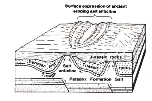
As the youngest layers on top of the salt and cap rock eroded away, the jointed sandstone became exposed at the surface. This subjected the sandstone to the elements!
The open spaces where the rock was cracked open allowed water to flow in, which dissolved away the salt that has been exposed beneath the sandstone. Eventually the dome became depleted of the evaporites and collapsed to create a valley. Thin sandstone rock walls called fins, named for looking like fish fins, are the remnants of this process. The space between each fin ever widens as the sandstone erodes over time.
The bulging of the salt diapir folded the northern layers of Salt Valley into an anticline where Delicate Arch is located. Faults erupted in the crust when the salt was dissolved by groundwater, collapsing the anticline. There are 4 substantial east-west trending normal faults in the area. (Doelling, 1985, 2000)

Water and wind are the main actors in Arch Formation.
Wind travels relatively uninhibitedly throughout this desert landscape, as there are not large trees to slow it down. It essentially acts as a sand blaster that can whip with reckless abandon on these surfaces.
Roughly 9 inches of rain fall annually in the area. The slightly acidic rain water combines with carbon dioxide in the atmosphere creating a weak carbonic acid. This erodes the fins by dissolving the cement, calcium carbonate, that hold the quartz grains together. This is a chemical weathering process! When the cement dissolves, the sand grains accumulate on the surface of the sandstone to soon be transported away, slimming the surface grain by grain.
Entrada Sandstone’s crossbedding makes it susceptible to weathering known as “exfoliation” where slabs of sandstone peel from the bedrock in concentric layers (Harris et al.,1997). Exfoliation is also known as onion skin weathering!
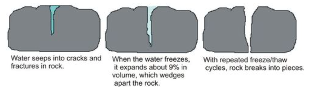
In the winter months, water seeps into cracks in the fins and freezes into ice. The expansion of the water as it freezes acts as a wedge that opens the rock, further opening up the crack. This is a physical weathering process called “ice-wedging”. Temperatures in the park can oscillate between freezing and melting in the span of one day so this process is constantly reworking the landscape.
In some fins, the exposed layer of weaker rock lays beneath a stronger layer. The weaker rock will weather first and undercut the more resistant layer above it. This opens a hole. The top of the hole is the weakest part because it is heavy and unsupported. Gravity causes fractures and breaks off pieces. This process opens the holes into windows and windows into eventual arches.
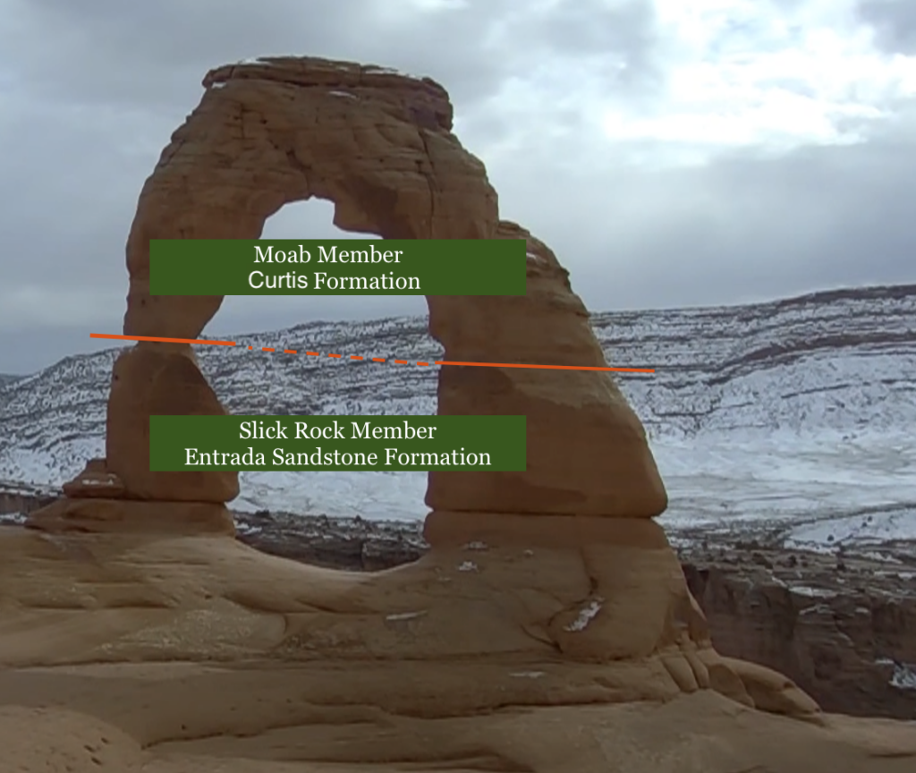
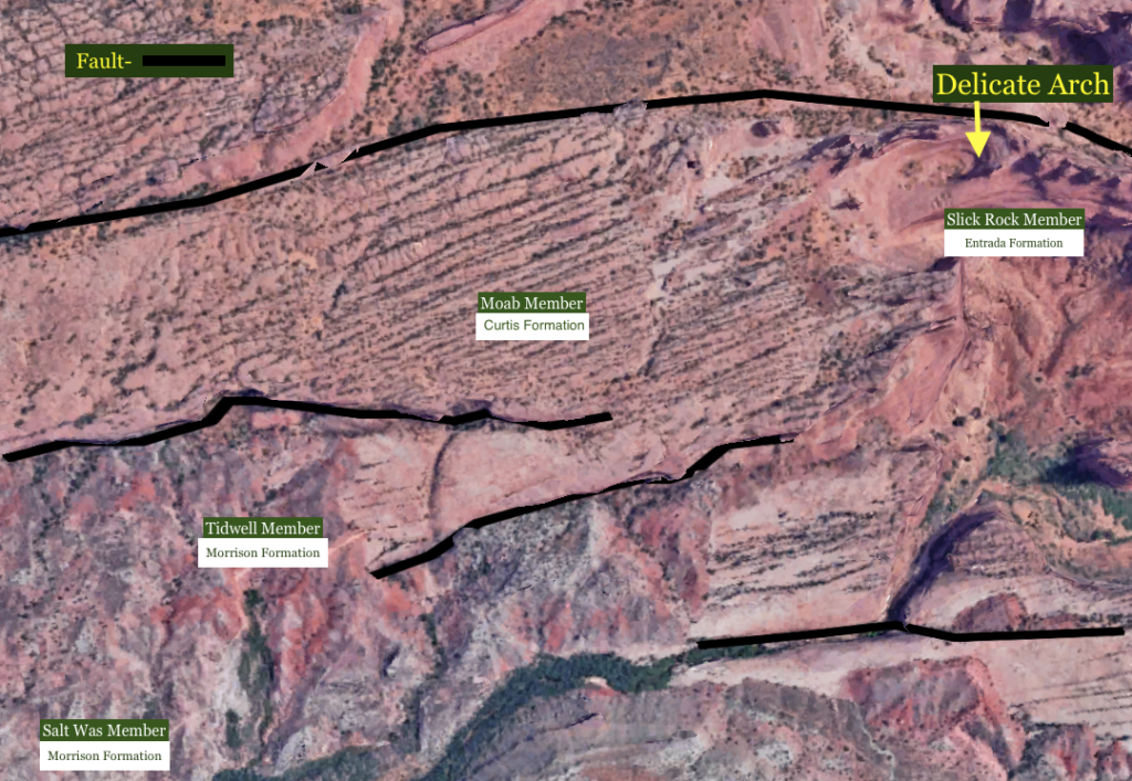
The Curtis Formation consists of sandstone interbedded with mudstone, limestone, and gypsum. The green iron- bearing micaceous mineral, glauconite, and marine invertebrate fossils indicate a shallow marine depositional environment during the mid-late Jurassic.
The upper part of Delicate Arch is the Curtis Formation while the lower part of the arch is Entrada Sandstone.
There is a plane of weakness at the contact between where water is able to enter.

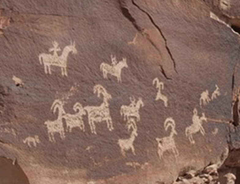
The Ute people, the Native American tribe that presided over the area for hundreds to thousands of years have a deep cultural spiritual connection to land here and Delicate Arch was a significant sphere for the Ute. Just off the trail to Delicate Arch there are wonderful petroglyphs portraying big horn sheep and equestrians. The tribal connections in the area are abundant and it is no wonder why!
One can imagine how unbelievable Delicate Arch would appear in the year 1300.
Please explore out other virtual field trips to learn more about Arches National Park and other locations!
Author: BreeAnn Getman