
Research
The focus of my research is geomorphology, the study of surface processes and landscape evolution on Earth and other planets. On Earth, the atmosphere, lithosphere, hydrosphere, and biosphere interact to produce our environment, on which all life depends. Such interactions include physical and chemical weathering of bedrock, which determines groundwater storage and soil nutrient supply and modulates natural hazards such as landslides and earthquake shaking. Below I summarize my group’s main research topics.
Tectonic Geomorphology – Topographic Stress
My research focuses on investigating how topographic stress, resulting from the interaction between tectonics and topography, controls bedrock fractures, surface processes, and landscape evolution. Although theoretical studies have suggested that topographic perturbation of regional stress fields may impact bedrock fractures and rock strength, few studies have tested this idea in natural landscapes. My group and I provided theoretical predictions of 3D topographic stress patterns in various topographic settings and tectonic stress regimes. We examined the observable consequences of topographic stress in real landscapes such as near-surface bedrock fractures, bedrock weathering, erodibility, landslides, and groundwater flow (St.Clair, Moon et al., 2015, Science; Moon et al., 2017, JGR-ES, Moon et al., 2020 , GRL, Li and Moon, 2021, Nature Geoscience ).
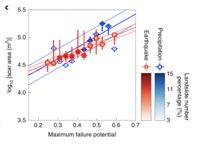
Fig. 1. Strong positive correlations between the upper bound of bedrock landslide area and the maximum failure potential, a proxy for the extent of open fracture zone in the subsurface. Figure from Li and Moon (2021, Nature Geosciences)
Quantitative Geomorphology and Geochronology
My group quantifies rates, timing, and distributions of various surface processes, including erosion, weathering, and sediment deposition, using novel geochronological methods (e.g., cosmogenic radionuclides or luminescence dating). My group also uses multiple field-, laboratory-, and modeling-based approaches to assess the varying impacts of tectonic, climatic, and bedrock controls on surface processes and landscape evolution in natural landscapes. We have worked on various locations in northern and southern California, Baja California, the Tibetan Plateau, and the Himalayas.
(Moon et al., 2011, Nature Geoscience; Moon et al., 2015, JGR-ES; Moon et al., 2018, EPSL, Brown and Moon, 2019, Lin et al., 2019, Kirkpatrick et al., 2020, Geology, Saha et al., 2021, GRL).
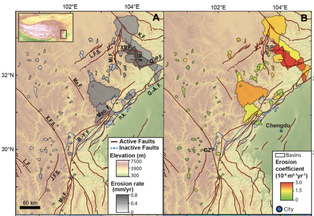
Fig. 2. Maps of eastern Tibet showing elevation, with sampled basins color-coded by (A) 10Be-derived erosion rate and (B) erosion coefficient. Figure from Kirkpatrick et al., (2021, Geology)
Critical Zone Sciences – Weathering
My group’s work involves quantifying chemical weathering rates from hillslope scales to global scales using chemical analysis of critical zone and river water and numerical model of steady-state weathering. For example, I use a rigorous mathematical method (e.g., inverse modeling, bootstrap analysis) to quantify the rates and uncertainties of silicate weathering and to understand the climatic, tectonic, and hydrological controls on chemical weathering processes. (Moon et al., 2007, GCA; Moon et al., 2009 AG; Moon et al., 2014, GCA; Ibarra et al., 2016, GCA; Goodfellow et al., 2016, JGR-ES; Ibarra et al., 2017, AG)
Planetary Surfaces
My research interest expands to the planetary surfaces of the Moon, Mars, and Titan in recent years. Recent collaborative work with Prof. Mitchell shows that the regional patterns of extreme methane precipitation rates may influence the alluvial fan formation on Titan’s surface (Faulk et al., 2017, Nature Geoscience). I also examine the spatial variation of surface roughness and modeled ice stability on the surface and subsurface in permanently shadowed regions (PSRs) in the lunar south polar region (Moon et al., 2021, GRL). A recent collaboration with Prof. An and Prof. Day examined the glacial features on Mars (Yin et al., 2021, Icarus).
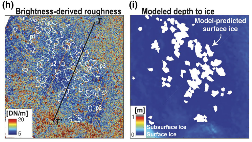
Fig. 3. Maps of Scott-E crater showing brightness-derived roughness (left) and modeled depth to thermally stable water ice (right). The roughness values significantly decrease where stable surface ice is predicted in thermal models. Figure from Moon et al., (2021, GRL)
Press Release
2022 Sloan Fellows from UCLA (link)
‘Bedrock landslide sizes controlled by topographic stress‘ by British Society of Geomorphology Newsletter, 2021 (link)
‘Imaging technique could help identify where landslides are likely’ by UCLA Newsroom, 2021 (link)
‘The View from Above: Drones Take UCLA Earth Science Sky High’, article by Emmons McKinney in UCLA EPSS Newsletter 2017 (link)
‘Intense storms batter Saturn’s largest moon, UCLA scientists report’ by UCLA Newsroom, 2017 (link)
‘Technique for analyzing bedrock could help builders, planners identify safe building zones’ by UCLA Newsroom, 2015 (link)